Helping the Stasi
 The Ministerium für Staatssicherheit (MfS - Ministry for State Security, better known by the acronym Stasi) and more precisely its Main Department No.3
(Hauptabteilung III, HA III) responsible for Signal Intelligence (SIGINT), was dependent on the East German military aviation to carry out its airborne SIGINT missions.
Since the aircraft (An-2, An-26, Mi-8) and their crew were not always available, it was decided to call the Soviets to the rescue to support some particular missions from 1983 on
(see also > Reconnaissance and Electronic Warfare, Part 7).
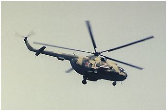
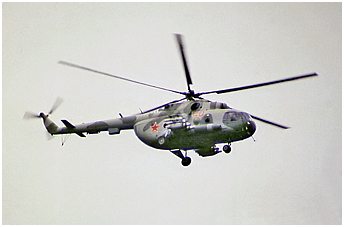
A handful of helicopters of the 239.OGVP from Oranienburg, a unit directly subordinate to 16.VA Headquarters, was made available to the German intelligence services as part
of the operation code named RELAIS II, between 1983 and 1989.
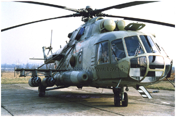
These helicopters - first a Mi-8T and then several Mi-8MT (1) - were equipped with various multiband receivers whose antennas were located
on the right side of the front fuselage replacing the portholes.
The Ministerium für Staatssicherheit (MfS - Ministry for State Security, better known by the acronym Stasi) and more precisely its Main Department No.3
(Hauptabteilung III, HA III) responsible for Signal Intelligence (SIGINT), was dependent on the East German military aviation to carry out its airborne SIGINT missions.
Since the aircraft (An-2, An-26, Mi-8) and their crew were not always available, it was decided to call the Soviets to the rescue to support some particular missions from 1983 on
(see also > Reconnaissance and Electronic Warfare, Part 7).
A handful of helicopters of the 239.OGVP from Oranienburg, a unit directly subordinate to 16.VA Headquarters, was made available to the German intelligence services as part
of the operation code named RELAIS II, between 1983 and 1989.
These helicopters - first a Mi-8T and then several Mi-8MT (1) - were equipped with various multiband receivers whose antennas were located
on the right side of the front fuselage replacing the portholes.
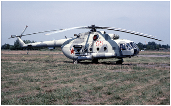
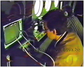 Les consoles des opérateurs est-allemands à bord d'un Mi-8 du 239.OGVP lors d'une mission "RELAIS" le long des frontières de
Berlin-Ouest. © V.Liebscher.
Les consoles des opérateurs est-allemands à bord d'un Mi-8 du 239.OGVP lors d'une mission "RELAIS" le long des frontières de
Berlin-Ouest. © V.Liebscher.
East German operators aboard a Mi-8 of the 239.OGVP during a "RELAIS"
mission along the West-Berlin borders. © V.Liebscher.
 Whereas the flight crew was Soviet, the personnel located inside the cargo hold were East German. At the beginning,
there was only one operator; however, he was later joined by an interpreter, a photographer and a second radio operator.
Intelligence flights (Erkundungsflügen) took off from Oranienburg and followed a route all along the borders of West-Berlin in a clockwise direction.
In the beginning, the missions were flown in periods of three days and then one week each month. The first mission took place on September 27, 1983. By the end of 1989,
more than sixty such "flying weeks" had been completed. The repetitive nature of the missions was meant to get the guys of the other side accustomed to them to weaken their vigilance.
Also, as Oranienburg was an airbase regularly overflown by the Allied military liaison mission aircraft, HA III personnel used a genuine Soviet UAZ-469 standard jeep with original
camouflage as a means of transport to reach the airfield in order not to be discovered. As a matter of fact, until the GDR ceased to exist, it remained a secret that an MfS
reconnaissance unit had operated a GSFG helicopter.
Whereas the flight crew was Soviet, the personnel located inside the cargo hold were East German. At the beginning,
there was only one operator; however, he was later joined by an interpreter, a photographer and a second radio operator.
Intelligence flights (Erkundungsflügen) took off from Oranienburg and followed a route all along the borders of West-Berlin in a clockwise direction.
In the beginning, the missions were flown in periods of three days and then one week each month. The first mission took place on September 27, 1983. By the end of 1989,
more than sixty such "flying weeks" had been completed. The repetitive nature of the missions was meant to get the guys of the other side accustomed to them to weaken their vigilance.
Also, as Oranienburg was an airbase regularly overflown by the Allied military liaison mission aircraft, HA III personnel used a genuine Soviet UAZ-469 standard jeep with original
camouflage as a means of transport to reach the airfield in order not to be discovered. As a matter of fact, until the GDR ceased to exist, it remained a secret that an MfS
reconnaissance unit had operated a GSFG helicopter.
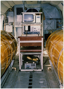
 One piece of equipment used to carry out these electronic intelligence missions was of Western origin, obtained despite the embargo that affected the GDR for this type
of sensitive technology. It was an Ailtech 757 spectrum analyzer that covered a wide range of frequencies up to 22 GHz.
A camera that recorded the display screen could be attached to it. The recording made it possible to document collection results that could be evaluated afterwards with the proven
route/time diagram.
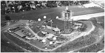
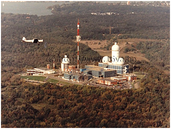
In addition to electronic intelligence, these flights also offered the opportunity to take pictures from the right rear cabin window to document military installations such as
communication or ELINT sites. A video camera mounted on a stabilised platform, was sometimes used to identify more easily the places where photographs had been taken. It was also
a good way to estimate the position of the antennas observed during the flight. Experimental use of thermal imaging also was tested, but without much success. Photography also was
used for more down-to-earth purposes such as surveying border crossings to improve safety measures.
One piece of equipment used to carry out these electronic intelligence missions was of Western origin, obtained despite the embargo that affected the GDR for this type
of sensitive technology. It was an Ailtech 757 spectrum analyzer that covered a wide range of frequencies up to 22 GHz.
A camera that recorded the display screen could be attached to it. The recording made it possible to document collection results that could be evaluated afterwards with the proven
route/time diagram.
In addition to electronic intelligence, these flights also offered the opportunity to take pictures from the right rear cabin window to document military installations such as
communication or ELINT sites. A video camera mounted on a stabilised platform, was sometimes used to identify more easily the places where photographs had been taken. It was also
a good way to estimate the position of the antennas observed during the flight. Experimental use of thermal imaging also was tested, but without much success. Photography also was
used for more down-to-earth purposes such as surveying border crossings to improve safety measures.
 A typical flight lasted about 100 minutes at an altitude of 100 meters and a speed of 110 km/h. When necessary, the helicopter could climb up to 200-300 meters and fly at a lower
speed to photograph some targets. Nevertheless, the flight pattern was not fixed and some measures could require climbing up to 1600 meters. The information collected by the German
agents was, of course, shared with their Soviet counterparts, the KGB.
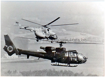
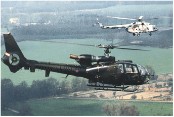
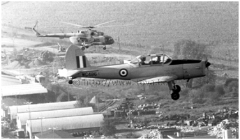
The Mi-8 often were accompanied by helicopters of the Western allies flying on their own side of the border. The French and the British with their Gazelles, were particularly
active and conspicuous. The British crews undertook regular photoshoots. Two Gazelle AH.1 of 7th Flight would fly together, one taking photos of the other with the Mi-8 in the background.
Although located inside the Berlin Control Zone, West Berlin had the same sovereign status as the FRG. The city could not be overflown below 3,000 meters by Soviet military aircraft
and that is why the Mi-8s only flew along the border.
A typical flight lasted about 100 minutes at an altitude of 100 meters and a speed of 110 km/h. When necessary, the helicopter could climb up to 200-300 meters and fly at a lower
speed to photograph some targets. Nevertheless, the flight pattern was not fixed and some measures could require climbing up to 1600 meters. The information collected by the German
agents was, of course, shared with their Soviet counterparts, the KGB.
The Mi-8 often were accompanied by helicopters of the Western allies flying on their own side of the border. The French and the British with their Gazelles, were particularly
active and conspicuous. The British crews undertook regular photoshoots. Two Gazelle AH.1 of 7th Flight would fly together, one taking photos of the other with the Mi-8 in the background.
Although located inside the Berlin Control Zone, West Berlin had the same sovereign status as the FRG. The city could not be overflown below 3,000 meters by Soviet military aircraft
and that is why the Mi-8s only flew along the border.
 An accidental overflight occurred once in the Treptow/Neukölln area without triggering any reaction from the West. In November 1983,
a West Berlin newspaper wrongly reported the overflight of Spandau.
An accidental incursion across the border was of concern to Erich Mielke, head of the MfS, mainly in relation to safety aspects. This is how the final authorization before the first
mission was granted only five days earlier by the Minister, after those of the KGB in Karlshorst and the GSFG in Wünsdorf. To avoid any diplomatic incident in case of a forced landing
in the West, the East German agents did not carry any official documents and were instructed to remain aboard the Mi-8. Some documents, such as notes taken in flight, were for a while
recorded on water-soluble paper so a canister of water was aboard. In 1984, Major General Männchen, HA III chief, prepared a plan to fly over the territory of West Berlin to expand the
scope of intelligence gathering! However, this did not go beyond the study phase probably because the idea did not receive official approval.
Up to the demise of the GDR, these operations were conducted at a high level of activity and were very successful.
An accidental overflight occurred once in the Treptow/Neukölln area without triggering any reaction from the West. In November 1983,
a West Berlin newspaper wrongly reported the overflight of Spandau.
An accidental incursion across the border was of concern to Erich Mielke, head of the MfS, mainly in relation to safety aspects. This is how the final authorization before the first
mission was granted only five days earlier by the Minister, after those of the KGB in Karlshorst and the GSFG in Wünsdorf. To avoid any diplomatic incident in case of a forced landing
in the West, the East German agents did not carry any official documents and were instructed to remain aboard the Mi-8. Some documents, such as notes taken in flight, were for a while
recorded on water-soluble paper so a canister of water was aboard. In 1984, Major General Männchen, HA III chief, prepared a plan to fly over the territory of West Berlin to expand the
scope of intelligence gathering! However, this did not go beyond the study phase probably because the idea did not receive official approval.
Up to the demise of the GDR, these operations were conducted at a high level of activity and were very successful.
This section is based on the book of Volker Liebscher entitled "Relais" (see > Multimedia) and his artilce entitled "Many's Spies" published in the June 2017 issue of Aeroplane. Adapted with permission of the author and the editor.
 |
 |
Download the Google Earth file with the potential targets of the Mi-8s and their flight path > Here. File created by Manfred Bischoff.
notes
(1)
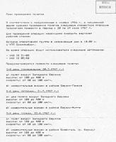
Known numbers:
Mi-8T '16'
Mi-8MT '34' c/n 93350 or 94350, '40' c/n 93361, '49' c/n 93344
Mi-8MTV-2 '05' c/n 94446
 |
The Mi-8 < Part 1 | < Part 2 | < Part 3 | < Part 4 | < Part 5 | < Part 6 |
| Plan du site - Sitemap |